
Pilot sites
The tool to be developed in this project for the simulation of MORLEs crisis will be validated in two pilot areas of 500 km2 each; the Cauterets Valley (Hautes Pyrénées) and the Arán Valley (Lérida).
Description of the pilot sites:
- Cauterets-Barège:
The valleys of Cauterets-Barège are located in the intra-Pyrenean climate zone (with oceanic and mountainous influences). These are representative of the climatic, lithological, geomorphological and land use conditions observed in the French central Pyrenees and are highly affected by natural hazards such as landslides, rock falls, debris flows and sudden floods. The peculiarity of these two valleys is that they juxtapose various types of fractured lithology (granite, limestone, shale and sandstone), which form reliefs of different elevation, and which have different degrees of exposure depending on their orientation. Cauterets, can be subdivided into two geomorphological units. The southern unit, dominated by plutonic igneous rocks (especially granites) superposed by limestones, and the western and eastern units, formed by metamorphic rocks (especially shales and sandstones) with limestone intercalations. In this valley the slopes above 1600 m.a.s.l and with an east orientation have more sun in summer and are more exposed to snowfall in winter than the bottom of the valley or the slopes exposed to the west. On the other hand, the Barège valley can also be divided into two main geomorphological units, the first located in the northwest of the valley and characterized by limestone and the second in the south dominated by metamorphic rocks. In Barège, the north-facing slopes are exposed to heavy snowfall in winter, while the south-facing slopes receive more sun all year round.
A recent inventory in the Cauterets Valley counted more than 100 active landslides (from deep to shallow landslides). For them, some triggering rain thresholds have been established (SAMCO project).

Figure 1. Planar shale landslide in the Cauterets Valley (Source: Bureau de Recherches Géologiques et Minières)
- Arán Valley:
The Aran Valley administrative region, located in the Spanish part of the Central Pyrenees has a total population of about 10.000 inhabitants. The study area is a typical high mountain valley of glacial origin where the climate is dominated by two factors: the prevailing west winds from the Atlantic Ocean, and the orographic effects of the Pyrenees. Precipitations in the study area have historically triggered landslides is as-sociated with two main rainfall patterns: prolonged rainfall episodes inthe autumn or spring, and convective rainstorms in summer. In winter,precipitation is mostly snowfall, which can contribute to landslide trig-gering conditions when melting. Several episodes of high landslide activity have affected the area along the 20th century. The most relevant ones are also associated to flood events: October 1907, August 1963, and September/November1982 (Hürlimann et al., 2003; Victoriano et al., 2016).
The 2013 landslide episode (Shu, H. et al., 2019):
An important landslide event occurred in the Central Pyrenees after a heavy rainfall episode in the 17th and the 18th of June 2013. This event also caused exceptional flooding of the Garonne and Noguera Pallaresa river valleys, and the total economic losses were estimated superior to 100 million euros. The flooding and landsliding events were caused by the combination of two exceptional factors: (i) extreme rainfall (124.7 mm in 48 h, ofwhich 101.2 mm fell on the 18th June) and (ii) high meltwater volumes after an unusually heavy snowfall during the winter. Landslides were especially noticeable in the Arán valley, where over 400 slope movements were identified in an area of 336 km2. These could be divided into three types considering the updated Varnes classification: (i) small and shallow planar slides, which mostly involved uppermost soil layer (Figure 2a), (ii) large slope failures (translational aswell as rotational slides), which include thicker soil layers and some-times also weathered bedrock (Figure 2b); and (iii) debris avalanches (also called hill-slope debrisflows), which formed a narrow pathdown the slope until the debris spread out at the bottom of the slope (Figure 2c, d).
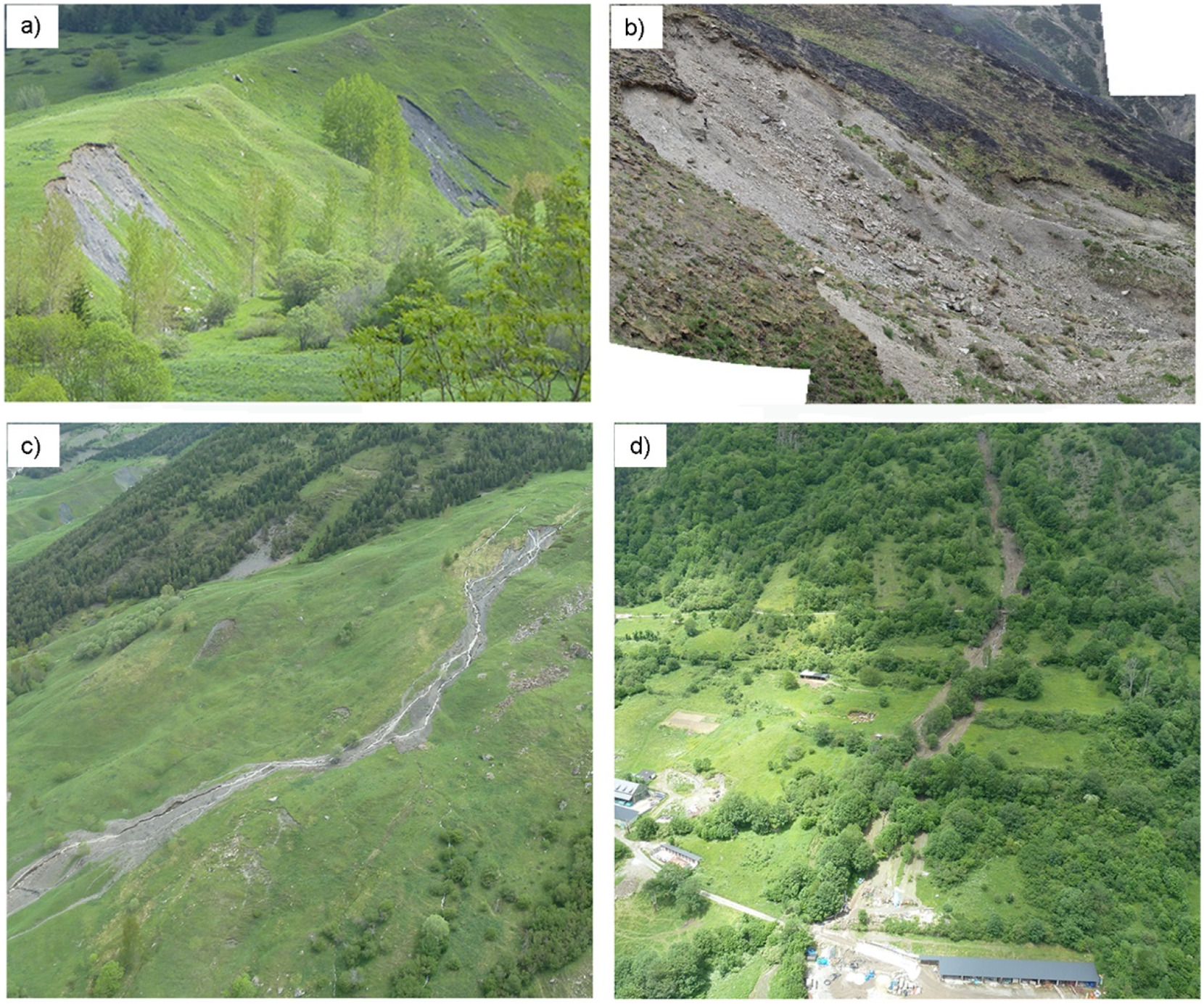
Figure 2. Photographs of the different landslide types that occurred during the 2013 episode: (a) small shallow landslides, (b) large slope failures, and (c, d) hill-slope debris flows. (Sources: Shu, H. et al., 2019; Pinyol et al. 2017)